Positioning of persons (localisation)
Outdoor
In public spaces, outside of buildings, localisation is possible via the so called Global Navigation Satellite System (GNSS), which operates trough radio signals from space satellites. In Europe the Global Positioning System (GPS) or the Galileo System are being used. These systems make it possible to define the exact position from +-10 m outdoors. These services are provided for free.
Indoor
The GNNS signal cannot be received inside of buildings, that´s why it is necessary to install at least one of the following systems:
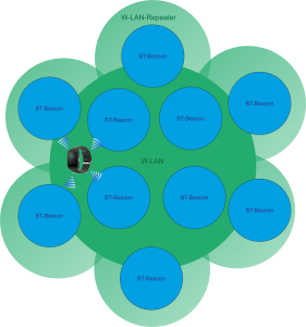
- WiFi for communication und localisation with an exactness from +-10 m. Wifi for communication and localisation with precision of +-10m.
- Bluetooth Low Energy (BLE) for localisation with an exactness of +-2m. NFC (Near Field Communication) for localisation with an exactness from +-0,3 m. Using a barometer it is possible to measure the air pressure and the height above the sea level, these information allows it to determine the floor a person is at the very moment.
Which of these technologies are being used depends on the system requirements and the costs.
Geofencing
With the help of Geofencing an electronic shelter is constructed. If a patient leaves this zone a signal is activated and actions to help can be initiated. The notification is based on the current localization and the comparison with a virtual map. The safety zone can be noted on a map or a building plan and then be uploaded on the eCallAid sensor. From then on the eCalAid sensor works autonomously and reports if the safety is zone is left.